Your intrepid blogger is visiting the Florida Keys with Mike this week, my first visit ever. As I am always intrigued by weather phenomena, today’s blog is about a very big hurricane that struck Florida before the days of weather tracking and warning systems.
The Florida Keys are today very heavily commercialized with hundreds of hotels, restaurants and water-related entertainment opportunities (think sport fishing, diving and boating). Sure, you can still find the occasional public beach and there are a number of causeways that parallel Highway 1 for people to stroll or fish from, but, for the most part, automobile traffic is heavy and and public views of the water from land are few and far between.
It wasn’t always like this. Until the early 1900s, only the very rich vacationed there (arriving by boat/yacht) and the relatively few locals earned a living by fishing and running hotels and eateries that catered to the visitors. What changed the Keys’ main industry focus to tourism was that Florida hotelier Henry Flagler decided to build a railroad through the Keys so that “general” tourism could find a foothold there (and people would stay in his hotels). That railroad was completed in 1912 and the people came. These days, about 80,000 people call the Keys home, with another 40,000 visiting annually.
A note about geography: The Florida Keys are in essence a series of small islands that extend south of the Florida mainland for about 100 miles. They are arranged in the shape of a comma, with the tip – Key West – being the southernmost point of the United States. Today, a highway connects the Keys but for many years the only way in and out was by rail.
In the summer of 1935, many WWI veterans were working as government employees to build a road on and over the Keys to replace the railroad which by this time was bankrupt. They lived in three work camps in the Middle Keys which were set up in areas where the beach was wide enough to accommodate some buildings. In these lean economic years, the men earned a paycheck on top of having room (in tents and plywood barracks) and board provided.
At the end of August, a tropical low in the Caribbean Sea gathered strength and worked its way west. Storm warnings were issued over the Labor Day weekend, but the strength of the storm was not known. It turned out to be the strongest hurricane to strike the United States to that date. The storm’s barometric pressure was measured at 26.35 millibars, the lowest ever recorded in the country – a record that still stands.
With no modern tracking systems, when the storm headed for Keys and intensified to a Category 5 hurricane, no one knew what was in store. Based on the initial severe storm warnings, the locals had boarded up windows, stored water, cooked food to last for a few days and gotten ready to ride it out. The government sent a locomotive and some cars into the Keys to pick up their employees and others but due to a series of unforeseen events, the train was delayed and got there just after 8 p.m. The 18-foot storm surge hit 20 minutes later. There was no place to hide and no way for the train to proceed. The rail cars were swept off the tracks as the water swirled over the sea-level land. More than 300 veterans died, along with 200+ residents of the Keys. The Middle Keys were denuded of foliage and anything else that was not tied down.
Sadly, in the aftermath as bodies were found, they were not allowed to be shipped back to the mainland so had to be cremated in the Keys. Families were denied the comfort of a memorial service and burial for their loved ones.
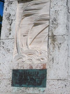
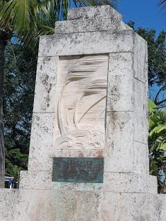
Two years later, a monument was built by the WPA and installed in Islamorada. The ashes of more than 300 victims of the storm are interred within it. The bas relief carving of the stylized palm trees and waves give a hint as to the fury of the storm.
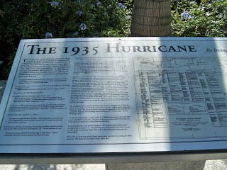
There are two stand-alone “tables” behind the monument. One describes the storm’s approach and immediate aftermath. The second gives a history of the monument’s construction and dedication. It uses a copy of what appears to be an official listing of all of the veterans who died that terrible night, including their WWI unit and rank. Although it is in very small print, it packs an emotional punch. That list is shown below on the right side.
The monument is at mile marker 81.8 on U.S. Highway 1.
It occurred to me while visiting the monument and reading more about that storm that as terrible as Andrew, Katrina, Sandy and so many hurricanes have been in the past 25 years or so, the human loss of life has most often been due to people ignoring the warnings to get out ahead of time. We’re so lucky to have the warning systems and evacuation procedures in place. Those who lost loved ones in the 1935 Labor Day hurricane would have given anything to have had their folks benefit then from what we have today.
The CAF Red Tai
