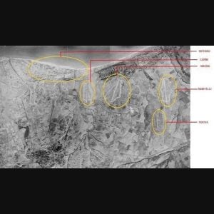
This is an aerial photograph of the Campomarino plain taken September 9, 1945, provided by the Istituto Geografico Militare. Outlined are the airfields in use during World War II, including the segregated Ramitelli Air Field, used by the Tuskegee Airmen when they were flying bomber escort missions into central and eastern Europe for the 15th Air Force.
The photo was taken from an altitude of 7500m at a scale of 1:55000. The area depicted here is east of the town of Termoli (Molise region, province of Campobasso) and is located between the river Biferno to the west and the river Saccione to the east, both visible on the right and left side of the photograph..
The airfield coordinates were:
BIFERNO airfield runway & dispersal: 41°57’34.95″N, 15°2’55.67″E;
CANNE airfield runway & dispersal: 41°55’50.77″N, 15°3’45.91″E;
MADNA airfield runway & dispersal: 41°55’10.99″N, 15°4’46.76″E;
RAMITELLI airfield runway & dispersal: 41°53’53.25″N, 15° 6’48.17″E;
NUOVA Airfield 41°53’3.02″N, 15°4’57.12″E


